|
| at: |
Bienville National Forest |
Data from USFS GIS
 show on map
 animate
Trail users:


Elevation Profile
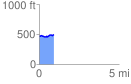
 0.905457 mi
 70.53 ft
 47.38 ft
 23.15 ft
 1.48 %
GPX Downloads: Track Route
![]()
|
| at: |
Bienville National Forest |
show on map
animate
0.905457 mi
70.53 ft
47.38 ft
23.15 ft
1.48 %