|
| at: |
Bienville National Forest |
Data from USFS GIS
 show on map
 animate
Trail users:


Elevation Profile
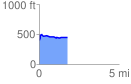
 1.796495 mi
 132.29 ft
 85.89 ft
 46.40 ft
 1.39 %
GPX Downloads: Track Route
![]()
|
| at: |
Bienville National Forest |
show on map
animate
1.796495 mi
132.29 ft
85.89 ft
46.40 ft
1.39 %