|
| at: |
Bienville National Forest |
Data from USFS GIS
 show on map
 animate
Trail users:


Elevation Profile
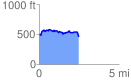
 2.471939 mi
 260.06 ft
 307.28 ft
 -47.21 ft
 2.35 %
GPX Downloads: Track Route
![]()
|
| at: |
Bienville National Forest |
show on map
animate
2.471939 mi
260.06 ft
307.28 ft
-47.21 ft
2.35 %