| at: |
Bienville National Forest |
Data from USFS GIS
 show on map
 animate
Trail users:


Elevation Profile
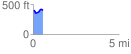
 0.571699 mi
 77.75 ft
 75.81 ft
 1.95 ft
 2.58 %
GPX Downloads: Track Route
![]()
| at: |
Bienville National Forest |
show on map
animate
0.571699 mi
77.75 ft
75.81 ft
1.95 ft
2.58 %