|
| at: |
Bienville National Forest |
Data from USFS GIS
 show on map
 animate
Trail users:


Elevation Profile
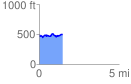
 1.483260 mi
 161.94 ft
 158.94 ft
 2.99 ft
 2.07 %
GPX Downloads: Track Route
![]()
|
| at: |
Bienville National Forest |
show on map
animate
1.483260 mi
161.94 ft
158.94 ft
2.99 ft
2.07 %