| at: |
DeSoto National Forest - Chickasawhay District |
Data from USFS GIS
 show on map
 animate
Trail users:


Elevation Profile
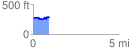
 0.935963 mi
 117.51 ft
 108.34 ft
 9.17 ft
 2.38 %
GPX Downloads: Track Route
![]()
| at: |
DeSoto National Forest - Chickasawhay District |
show on map
animate
0.935963 mi
117.51 ft
108.34 ft
9.17 ft
2.38 %