| at: |
DeSoto National Forest - Chickasawhay District |
Data from USFS GIS
 show on map
 animate
Trail users:


Elevation Profile
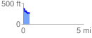
 0.529630 mi
 69.91 ft
 167.71 ft
 -97.80 ft
 6.00 %
GPX Downloads: Track Route
![]()
| at: |
DeSoto National Forest - Chickasawhay District |
show on map
animate
0.529630 mi
69.91 ft
167.71 ft
-97.80 ft
6.00 %