|
| at: |
DeSoto National Forest - Chickasawhay District |
Data from USFS GIS
 show on map
 animate
Trail users:


Elevation Profile
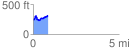
 0.859514 mi
 186.72 ft
 109.19 ft
 77.53 ft
 4.11 %
GPX Downloads: Track Route
![]()
|
| at: |
DeSoto National Forest - Chickasawhay District |
show on map
animate
0.859514 mi
186.72 ft
109.19 ft
77.53 ft
4.11 %