| at: |
DeSoto National Forest - Chickasawhay District |
Data from USFS GIS
 show on map
 animate
Trail users:


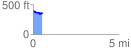
Elevation Profile
 0.536658 mi
 68.95 ft
 88.55 ft
 -19.59 ft
 3.12 %
GPX Downloads: Track Route
![]()
| at: |
DeSoto National Forest - Chickasawhay District |
show on map
animate
0.536658 mi
68.95 ft
88.55 ft
-19.59 ft
3.12 %