| at: |
DeSoto National Forest - Chickasawhay District |
Data from USFS GIS
 show on map
 animate
Trail users:


Elevation Profile
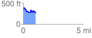
 1.035965 mi
 177.52 ft
 245.08 ft
 -67.56 ft
 4.48 %
GPX Downloads: Track Route
![]()
| at: |
DeSoto National Forest - Chickasawhay District |
show on map
animate
1.035965 mi
177.52 ft
245.08 ft
-67.56 ft
4.48 %