|
| at: |
DeSoto National Forest - Chickasawhay District |
Data from USFS GIS
 show on map
 animate
Trail users:


Elevation Profile
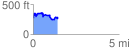
 1.464166 mi
 316.64 ft
 305.91 ft
 10.73 ft
 4.10 %
GPX Downloads: Track Route
![]()
|
| at: |
DeSoto National Forest - Chickasawhay District |
show on map
animate
1.464166 mi
316.64 ft
305.91 ft
10.73 ft
4.10 %