| at: |
DeSoto National Forest - Chickasawhay District |
Data from USFS GIS
 show on map
 animate
Trail users:


Elevation Profile
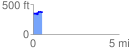
 0.538172 mi
 87.58 ft
 61.71 ft
 25.88 ft
 3.08 %
GPX Downloads: Track Route
![]()
| at: |
DeSoto National Forest - Chickasawhay District |
show on map
animate
0.538172 mi
87.58 ft
61.71 ft
25.88 ft
3.08 %