| at: |
DeSoto National Forest - Chickasawhay District |
Data from USFS GIS
 show on map
 animate
Trail users:


Elevation Profile
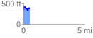
 0.519138 mi
 173.32 ft
 133.91 ft
 39.41 ft
 6.32 %
GPX Downloads: Track Route
![]()
| at: |
DeSoto National Forest - Chickasawhay District |
show on map
animate
0.519138 mi
173.32 ft
133.91 ft
39.41 ft
6.32 %