|
| at: |
DeSoto National Forest - Chickasawhay District |
Data from USFS GIS
 show on map
 animate
Trail users:


Elevation Profile
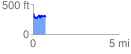
 0.705827 mi
 114.77 ft
 161.20 ft
 -46.42 ft
 4.33 %
GPX Downloads: Track Route
![]()
|
| at: |
DeSoto National Forest - Chickasawhay District |
show on map
animate
0.705827 mi
114.77 ft
161.20 ft
-46.42 ft
4.33 %