|
| at: |
DeSoto National Forest - Chickasawhay District |
Data from USFS GIS
 show on map
 animate
Trail users:


Elevation Profile
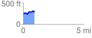
 0.946561 mi
 173.26 ft
 106.68 ft
 66.59 ft
 3.47 %
GPX Downloads: Track Route
![]()
|
| at: |
DeSoto National Forest - Chickasawhay District |
show on map
animate
0.946561 mi
173.26 ft
106.68 ft
66.59 ft
3.47 %