| at: |
DeSoto National Forest - Chickasawhay District |
Data from USFS GIS
 show on map
 animate
Trail users:


Elevation Profile
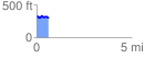
 0.631004 mi
 97.45 ft
 130.63 ft
 -33.17 ft
 3.92 %
GPX Downloads: Track Route
![]()
| at: |
DeSoto National Forest - Chickasawhay District |
show on map
animate
0.631004 mi
97.45 ft
130.63 ft
-33.17 ft
3.92 %