| at: |
DeSoto National Forest - Chickasawhay District |
Data from USFS GIS
 show on map
 animate
Trail users:


Elevation Profile
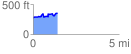
 1.430455 mi
 185.95 ft
 116.19 ft
 69.76 ft
 2.46 %
GPX Downloads: Track Route
![]()
| at: |
DeSoto National Forest - Chickasawhay District |
show on map
animate
1.430455 mi
185.95 ft
116.19 ft
69.76 ft
2.46 %