| at: |
DeSoto National Forest - Chickasawhay District |
Data from USFS GIS
 show on map
 animate
Trail users:


Elevation Profile
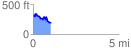
 1.047363 mi
 149.57 ft
 296.48 ft
 -146.91 ft
 5.36 %
GPX Downloads: Track Route
![]()
| at: |
DeSoto National Forest - Chickasawhay District |
show on map
animate
1.047363 mi
149.57 ft
296.48 ft
-146.91 ft
5.36 %