|
| at: |
DeSoto National Forest - Chickasawhay District |
Data from USFS GIS
 show on map
 animate
Trail users:


Elevation Profile
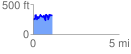
 1.114914 mi
 421.77 ft
 347.53 ft
 74.24 ft
 7.16 %
GPX Downloads: Track Route
![]()
|
| at: |
DeSoto National Forest - Chickasawhay District |
show on map
animate
1.114914 mi
421.77 ft
347.53 ft
74.24 ft
7.16 %