|
| at: |
DeSoto National Forest - Chickasawhay District |
Data from USFS GIS
 show on map
 animate
Trail users:


Elevation Profile
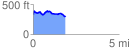
 1.893710 mi
 227.87 ft
 260.02 ft
 -32.15 ft
 2.60 %
GPX Downloads: Track Route
![]()
|
| at: |
DeSoto National Forest - Chickasawhay District |
show on map
animate
1.893710 mi
227.87 ft
260.02 ft
-32.15 ft
2.60 %