|
| at: |
DeSoto National Forest - Chickasawhay District |
Data from USFS GIS
 show on map
 animate
Trail users:


Elevation Profile
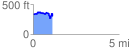
 1.149445 mi
 204.69 ft
 218.20 ft
 -13.52 ft
 3.60 %
GPX Downloads: Track Route
![]()
|
| at: |
DeSoto National Forest - Chickasawhay District |
show on map
animate
1.149445 mi
204.69 ft
218.20 ft
-13.52 ft
3.60 %