|
| at: |
DeSoto National Forest - Chickasawhay District |
Data from USFS GIS
 show on map
 animate
Trail users:


Elevation Profile
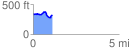
 1.104853 mi
 130.54 ft
 128.54 ft
 2.00 ft
 2.24 %
GPX Downloads: Track Route
![]()
|
| at: |
DeSoto National Forest - Chickasawhay District |
show on map
animate
1.104853 mi
130.54 ft
128.54 ft
2.00 ft
2.24 %