| at: |
DeSoto National Forest - Chickasawhay District |
Data from USFS GIS
 show on map
 animate
Trail users:


Elevation Profile
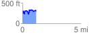
 1.197879 mi
 297.71 ft
 231.72 ft
 65.99 ft
 4.71 %
GPX Downloads: Track Route
![]()
| at: |
DeSoto National Forest - Chickasawhay District |
show on map
animate
1.197879 mi
297.71 ft
231.72 ft
65.99 ft
4.71 %