| at: |
DeSoto National Forest - Chickasawhay District |
Data from USFS GIS
 show on map
 animate
Trail users:


Elevation Profile
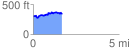
 1.663565 mi
 251.24 ft
 214.91 ft
 36.34 ft
 2.86 %
GPX Downloads: Track Route
![]()
| at: |
DeSoto National Forest - Chickasawhay District |
show on map
animate
1.663565 mi
251.24 ft
214.91 ft
36.34 ft
2.86 %