|
| at: |
DeSoto National Forest - Chickasawhay District |
Data from USFS GIS
 show on map
 animate
Trail users:


Elevation Profile
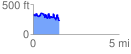
 1.534038 mi
 463.81 ft
 559.32 ft
 -95.51 ft
 6.91 %
GPX Downloads: Track Route
![]()
|
| at: |
DeSoto National Forest - Chickasawhay District |
show on map
animate
1.534038 mi
463.81 ft
559.32 ft
-95.51 ft
6.91 %