|
| at: |
DeSoto National Forest - Chickasawhay District |
Data from USFS GIS
 show on map
 animate
Trail users:


Elevation Profile
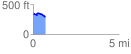
 0.721570 mi
 70.15 ft
 101.09 ft
 -30.94 ft
 2.65 %
GPX Downloads: Track Route
![]()
|
| at: |
DeSoto National Forest - Chickasawhay District |
show on map
animate
0.721570 mi
70.15 ft
101.09 ft
-30.94 ft
2.65 %