|
| at: |
DeSoto National Forest - Chickasawhay District |
Data from USFS GIS
 show on map
 animate
Trail users:


Elevation Profile
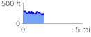
 1.792964 mi
 366.76 ft
 488.56 ft
 -121.80 ft
 5.16 %
GPX Downloads: Track Route
![]()
|
| at: |
DeSoto National Forest - Chickasawhay District |
show on map
animate
1.792964 mi
366.76 ft
488.56 ft
-121.80 ft
5.16 %