|
| at: |
DeSoto National Forest - Chickasawhay District |
Data from USFS GIS
 show on map
 animate
Trail users:


Elevation Profile
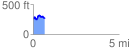
 0.673774 mi
 138.94 ft
 128.04 ft
 10.90 ft
 3.91 %
GPX Downloads: Track Route
![]()
|
| at: |
DeSoto National Forest - Chickasawhay District |
show on map
animate
0.673774 mi
138.94 ft
128.04 ft
10.90 ft
3.91 %