| at: |
Amicalola/Nimblewill/Tickanetley |
Data from David Muse
 show on map
 animate
Trail users:


Elevation Profile
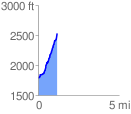
 1.196912 mi
 768.38 ft
 18.17 ft
 750.21 ft
 12.16 %
GPX Downloads: Track Route
![]()
| at: |
Amicalola/Nimblewill/Tickanetley |
show on map
animate
1.196912 mi
768.38 ft
18.17 ft
750.21 ft
12.16 %