| at: |
DeSoto National Forest - Chickasawhay District |
Data from USFS GIS
 show on map
 animate
Trail users:


Elevation Profile
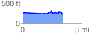
 3.415551 mi
 343.14 ft
 375.05 ft
 -31.90 ft
 2.08 %
GPX Downloads: Track Route
![]()
| at: |
DeSoto National Forest - Chickasawhay District |
show on map
animate
3.415551 mi
343.14 ft
375.05 ft
-31.90 ft
2.08 %