|
| at: |
DeSoto National Forest - Chickasawhay District |
Data from USFS GIS
 show on map
 animate
Trail users:


Elevation Profile
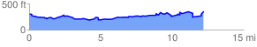
 12.361350 mi
 1109.55 ft
 1126.80 ft
 -17.25 ft
 1.73 %
GPX Downloads: Track Route
![]()
|
| at: |
DeSoto National Forest - Chickasawhay District |
show on map
animate
12.361350 mi
1109.55 ft
1126.80 ft
-17.25 ft
1.73 %