| at: |
DeSoto National Forest - Chickasawhay District |
Data from USFS GIS
 show on map
 animate
Trail users:


Elevation Profile
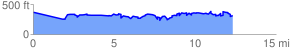
 12.602670 mi
 3226.61 ft
 3233.36 ft
 -6.75 ft
 4.86 %
GPX Downloads: Track Route
![]()
| at: |
DeSoto National Forest - Chickasawhay District |
show on map
animate
12.602670 mi
3226.61 ft
3233.36 ft
-6.75 ft
4.86 %