| at: |
DeSoto National Forest - Chickasawhay District |
Data from USFS GIS
 show on map
 animate
Trail users:

Elevation Profile
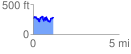
 1.172387 mi
 343.58 ft
 331.32 ft
 12.26 ft
 5.55 %
GPX Downloads: Track Route
![]()
| at: |
DeSoto National Forest - Chickasawhay District |
show on map
animate
1.172387 mi
343.58 ft
331.32 ft
12.26 ft
5.55 %