| at: |
Amicalola/Nimblewill/Tickanetley |
Data from David Muse
 show on map
 animate
Trail users:

Elevation Profile
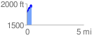
 0.448162 mi
 196.97 ft
 78.67 ft
 118.30 ft
 8.32 %
GPX Downloads: Track Route
![]()
| at: |
Amicalola/Nimblewill/Tickanetley |
show on map
animate
0.448162 mi
196.97 ft
78.67 ft
118.30 ft
8.32 %