| at: |
Amicalola/Nimblewill/Tickanetley |
Data from David Muse
 show on map
 animate
Trail users:

Elevation Profile
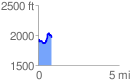
 0.834662 mi
 237.90 ft
 163.87 ft
 74.03 ft
 5.40 %
GPX Downloads: Track Route
![]()
| at: |
Amicalola/Nimblewill/Tickanetley |
show on map
animate
0.834662 mi
237.90 ft
163.87 ft
74.03 ft
5.40 %