| at: |
DeSoto National Forest - South |
Data from USFS GIS
 show on map
 animate
Trail users:


Elevation Profile
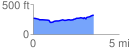
 3.533736 mi
 183.99 ft
 126.51 ft
 57.48 ft
 0.99 %
GPX Downloads: Track Route
![]()
| at: |
DeSoto National Forest - South |
show on map
animate
3.533736 mi
183.99 ft
126.51 ft
57.48 ft
0.99 %