|
| at: |
DeSoto National Forest - South |
Data from USFS GIS
 show on map
 animate
Trail users:


Elevation Profile
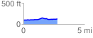
 2.755457 mi
 80.76 ft
 53.79 ft
 26.98 ft
 0.56 %
GPX Downloads: Track Route
![]()
|
| at: |
DeSoto National Forest - South |
show on map
animate
2.755457 mi
80.76 ft
53.79 ft
26.98 ft
0.56 %