| at: |
DeSoto National Forest - South |
Data from USFS GIS
 show on map
 animate
Trail users:


Elevation Profile
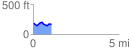
 1.054822 mi
 93.09 ft
 112.71 ft
 -19.62 ft
 2.02 %
GPX Downloads: Track Route
![]()
| at: |
DeSoto National Forest - South |
show on map
animate
1.054822 mi
93.09 ft
112.71 ft
-19.62 ft
2.02 %