| at: |
DeSoto National Forest - South |
Data from USFS GIS
 show on map
 animate
Trail users:


Elevation Profile
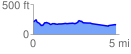
 4.805135 mi
 193.16 ft
 241.57 ft
 -48.41 ft
 0.95 %
GPX Downloads: Track Route
![]()
| at: |
DeSoto National Forest - South |
show on map
animate
4.805135 mi
193.16 ft
241.57 ft
-48.41 ft
0.95 %