| at: |
DeSoto National Forest - South |
Data from USFS GIS
 show on map
 animate
Trail users:


Elevation Profile
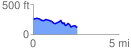
 2.552122 mi
 161.52 ft
 305.86 ft
 -144.35 ft
 2.27 %
GPX Downloads: Track Route
![]()
| at: |
DeSoto National Forest - South |
show on map
animate
2.552122 mi
161.52 ft
305.86 ft
-144.35 ft
2.27 %