| at: |
DeSoto National Forest - South |
Data from USFS GIS
 show on map
 animate
Trail users:


Elevation Profile
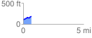
 0.683084 mi
 94.49 ft
 15.03 ft
 79.46 ft
 2.62 %
GPX Downloads: Track Route
![]()
| at: |
DeSoto National Forest - South |
show on map
animate
0.683084 mi
94.49 ft
15.03 ft
79.46 ft
2.62 %