| at: |
DeSoto National Forest - South |
Data from USFS GIS
 show on map
 animate
Trail users:


Elevation Profile
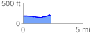
 2.344993 mi
 102.81 ft
 91.42 ft
 11.39 ft
 0.83 %
GPX Downloads: Track Route
![]()
| at: |
DeSoto National Forest - South |
show on map
animate
2.344993 mi
102.81 ft
91.42 ft
11.39 ft
0.83 %