| at: |
DeSoto National Forest - South |
Data from USFS GIS
 show on map
 animate
Trail users:


Elevation Profile
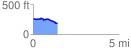
 1.449739 mi
 33.31 ft
 107.86 ft
 -74.56 ft
 1.41 %
GPX Downloads: Track Route
![]()
| at: |
DeSoto National Forest - South |
show on map
animate
1.449739 mi
33.31 ft
107.86 ft
-74.56 ft
1.41 %