| at: |
DeSoto National Forest - South |
Data from USFS GIS
 show on map
 animate
Trail users:


Elevation Profile
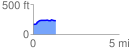
 1.318989 mi
 92.52 ft
 26.94 ft
 65.59 ft
 1.33 %
GPX Downloads: Track Route
![]()
| at: |
DeSoto National Forest - South |
show on map
animate
1.318989 mi
92.52 ft
26.94 ft
65.59 ft
1.33 %