| at: |
DeSoto National Forest - South |
Data from USFS GIS
 show on map
 animate
Trail users:


Elevation Profile
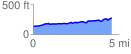
 4.563634 mi
 250.74 ft
 111.06 ft
 139.68 ft
 1.04 %
GPX Downloads: Track Route
![]()
| at: |
DeSoto National Forest - South |
show on map
animate
4.563634 mi
250.74 ft
111.06 ft
139.68 ft
1.04 %