| at: |
DeSoto National Forest - South |
Data from USFS GIS
 show on map
 animate
Trail users:


Elevation Profile
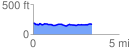
 3.444643 mi
 159.47 ft
 175.91 ft
 -16.43 ft
 0.97 %
GPX Downloads: Track Route
![]()
| at: |
DeSoto National Forest - South |
show on map
animate
3.444643 mi
159.47 ft
175.91 ft
-16.43 ft
0.97 %