| at: |
DeSoto National Forest - South |
Data from USFS GIS
 show on map
 animate
Trail users:


Elevation Profile
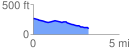
 3.217978 mi
 46.67 ft
 220.92 ft
 -174.25 ft
 1.30 %
GPX Downloads: Track Route
![]()
| at: |
DeSoto National Forest - South |
show on map
animate
3.217978 mi
46.67 ft
220.92 ft
-174.25 ft
1.30 %