| at: |
DeSoto National Forest - South |
Data from USFS GIS
 show on map
 animate
Trail users:


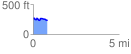
Elevation Profile
 0.844653 mi
 56.46 ft
 103.96 ft
 -47.49 ft
 2.33 %
GPX Downloads: Track Route
![]()
| at: |
DeSoto National Forest - South |
show on map
animate
0.844653 mi
56.46 ft
103.96 ft
-47.49 ft
2.33 %