|
| at: |
DeSoto National Forest - South |
Data from USFS GIS
 show on map
 animate
Trail users:


Elevation Profile
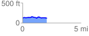
 2.091560 mi
 72.74 ft
 85.25 ft
 -12.51 ft
 0.77 %
GPX Downloads: Track Route
![]()
|
| at: |
DeSoto National Forest - South |
show on map
animate
2.091560 mi
72.74 ft
85.25 ft
-12.51 ft
0.77 %