| at: |
DeSoto National Forest - South |
Data from USFS GIS
 show on map
 animate
Trail users:


Elevation Profile
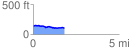
 1.834683 mi
 44.59 ft
 80.21 ft
 -35.63 ft
 0.83 %
GPX Downloads: Track Route
![]()
| at: |
DeSoto National Forest - South |
show on map
animate
1.834683 mi
44.59 ft
80.21 ft
-35.63 ft
0.83 %